Coal Seam Gas
and Coal Mining Water Knowledge Program
The Coal Seam Gas and Coal Mining Water Knowledge
Program aims to increase the available science for assessing water-related
impacts of future coal seam gas and coal mining proposals, and increase
decision-making transparency.
Program Partners
The program is being delivered by the Department of
Environment, Water and Natural Resources (DEWNR) in partnership with the
Alinytjara Wilurara, Eyre Peninsula, Northern & Yorke, SA Arid Lands, SA
Murray-Darling Basin and South East NRM Boards, the Department of Manufacturing,
Innovation, Trade, Resources and Energy (DMITRE), the Department of Premier and
Cabinet (DPC), the Northern Territory and Queensland Governments, the Goyder
Institute for Water Research, Lake Eyre Basin Rivers Assessment (LEBRA), Desert
Channels Group (Qld), Southern Gulf Catchments (Qld) and South West NRM
(Qld).
Independent Expert Scientific Committee Referral Protocol
The South Australian Protocol for the Referral of
Project Applications to the Independent Expert Scientific Committee on Coal Seam
Gas and Large Coal Mining Developments was published and implemented to
provide for transparent decision-making based on the best available science.
When a proposed development reaches the environmental
assessment stage, the South Australian Government uses the Protocol to determine
if the proposal is likely to have a significant impact on water resources. If
impacts are likely, the Independent Expert Scientific Committee (IESC) will
provide expert scientific advice to inform the State’s decision on whether the
development should be approved, and under what conditions.
Risk and vulnerability assessment framework
The risk and vulnerability assessment framework will
provide the tools to ensure that regulation of coal seam gas and coal mining
development is science based, consistent, transparent and relevant to community
concerns. The framework will be based on the AS/NZS ISO 31000:2009 risk
management guidelines.
Application of the risk and vulnerability framework
guides sustainable development decisions that consider the priorities of
stakeholders and the wider community.
NRM water asset database
This project will collate and ground-truth existing
data on water resources in the Alinytjara Wilurara, Eyre Peninsula, Northern
& Yorke, SA Arid Lands, SA Murray-Darling Basin and South East Natural
Resource Management (NRM) regions.
Regional data has been combined into a spatial database
which consistently characterises water assets and identifies vulnerabilities of
those assets to potential coal seam gas and coal mining developments.
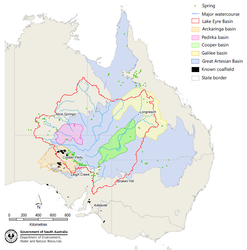
Groundwater assessments of the Arckaringa and Pedirka Basins
The Arckaringa and Pedirka geological basins are
identified as having high coal development potential, but there is limited
understanding about their hydrogeological characteristics.
This project has collated and reviewed existing
hydrogeological data and will further identify and address key knowledge gaps
through on-ground investigations.
Outcomes will include:
Key contributions to Bioregional Assessment baseline
data, modelling and risk analysis.
Basin architecture to map the geometry and extent of
basin units.
Groundwater numerical modelling.
Hydro-chemical sampling and targeted well drilling to
establish baseline conditions and better understand hydrological
processes.
Rivers and springs assessments in the Lake Eyre Basin
The Lake Eyre Basin Rivers Monitoring and Springs
Assessment projects are being delivered across the entire Lake Eyre drainage
basin, covering parts of South Australia, the Northern Territory and Queensland.
The focus is on areas that overlie the coal-bearing Arckaringa, Pedirka, Cooper
and Galilee Basins.
Outcomes will include:
Key contributions to Bioregional Assessment baseline
data, modelling and risk analysis.
Hydrological modelling.
Ecological modelling.
Fluvial geomorphological analysis.
Further characterisation of water assets including
springs, waterholes and floodplains.
The following map shows the extent of the program's focus areas across all
states. Click the map to view a larger version in a new window. See also the Fact Sheet providing an overview of the program.